Cloudy Skies and an Autumnal Cool Change: Your Thursday Outlook for Melbourne
Overview of the Day
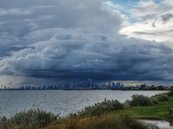
As Melbourne moves deeper into the autumn season, Thursday, 2 April 2026, is set to deliver a day characterized by increasing cloud cover and a late-day shift in conditions. Following a stable start to the week, a relatively weak cold front is making its way across the southeastern mainland. While most of the day will remain dry, Melburnians should prepare for a noticeable drop in temperature and the arrival of moisture as the sun goes down.
Morning: A Crisp and Cloudy Start
The morning begins on a cool note with temperatures starting at approximately 14°C. Early commuters can expect overcast skies and high humidity levels, reaching up to 72% before the midday sun attempts to break through. Sunrise occurred at 8:12 AM, and while the atmosphere may feel heavy, the threat of precipitation remains very low during the early hours. A light southwesterly breeze will be present, adding a slight chill to the air, so a jacket is highly recommended for those heading out early.
Afternoon: Peak Temperatures and High UV
By early afternoon, the mercury is expected to climb to a maximum of 21°C. Although the day is forecast to be mostly cloudy, residents are advised not to be complacent regarding sun safety. The UV index is predicted to reach a high of 8 today. Experts recommend sun protection between 11:00 AM and 3:00 PM, as ultraviolet radiation can penetrate through the cloud layer even on cooler days. The wind will remain relatively consistent, originating from the south and southeast as the cold front approaches.
Evening and Overnight: Shifting Winds and Late Showers
As we approach sunset at 8:04 PM, the weather will begin to turn more unsettled. The temperature will dip back toward 17°C by early evening, eventually settling at an overnight low of 14°C. While the chance of rain during the day is minimal at 10%, this probability increases to 35% after dark. These showers are expected to be light and intermittent, primarily impacting the southern suburbs and the Mornington Peninsula as the moist air is pushed inland by the change in wind direction.
Wind and Marine Notice
For those planning activities on Port Phillip Bay, be aware that a weak cold front will cause winds to shift to the south later this afternoon. Currently, winds are blowing from the Northeast at roughly 20-28 km/h (4 Beaufort), but they will become more southerly and potentially gusty toward the end of the day. There are currently no severe weather or flood warnings in place for the metropolitan area, but the incoming front will bring a damp end to the day and a cooler start to the coming weekend.

Ancient Rome, Fast Cars, and Disney Magic in Melbourne Today

Laughter, Legends, and the Big Build: Your Melbourne Friday Briefing
Major Disruptions on Eastern Freeway and Bulleen Road This Good Friday